Analysis
Handtke’s Map: Previously unseen 19th century map of Tigray includes Western Tigray and Eritrea
Researchers at Ghent University have published a previously unseen map of the Horn of Africa. The map was prepared by a German atlas printing house in the mid-19th century.

The map could be found at the National Library of Estonia. The map was made “in one of the few stronger cartographic publishing houses in 19th century Germany, managed by Carl Flemming (1806-1878).” The researchers wrote “Flemming was aided by cartographer Friedrich Handtke (1815-1879), who worked on nearly every map assignment for the firm (Brogiato and Fick 1997; Witkam 2007).”
The researchers wrote that the Red Sea Coast, Egypt, “Nubia” and the northern and central Ethiopian highlands were known and “Tigre”, “Amhara” wewe mapped in relative detail, and to the south with fuzzy boundaries for “Schoa”. “Amhara” corresponded largely to the current Amhara region, yet with Wollo as a separate entity.
The territorial map of Tigray (old spelling “Tigre”) included the “Eritrean highlands (“Baharnagasch”) and the current Tigray region, clearly comprising the current Western Tigray with “Walkayt” and “Waldubba”. By 1849, Eritrea had not yet come into existence as a separate territory (Ullendorff 1965).”
Other Relevant Maps and Resources:
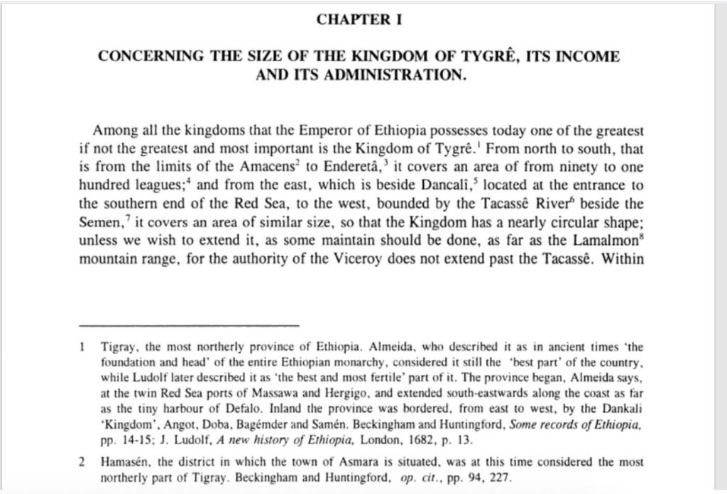
There are other sources that also show that Tigray was a lot bigger than (some times four times) what it is today. A book by Manoel Barradas: Tractatus Tres Historico-Geographici (1634). A Seventeenth Century Historical and Geographical Account of Tigray, Ethiopia shows the extent of Tigray in the 17th century. Professor Ghelawdewos Araia has summarized.
A screenshot of a page from Manoel Barradas’ book explaining the extent of Tigray: “From North to south, that is from the limits of the Amacens (Hammasiens) to Enderta”.
Another book, A VOYAGE TO ABYSSINIA by Jerome Lobo (1887), seems to include the Semien Mountains as part of a Tigrayan territory.
Indeed I never saw snow in Abyssinia, except on Mount Semen in the kingdom of Tigre, very remote from the Nile, and on Namera, which is indeed not far distant, but where there never falls snow sufficient to wet the foot of the mountain when it is melted.
The Ethiopian states of today are organized on the basis of people’s identity, culture and consent and it has provided ways for people to express their consent through referendum. But we believe these resources will help in countering the incessant, baseless and anti-constitutional claims by Amhara politicians of Western Tigray. It is important to note that Amhara, let alone owning Western Tigray prior to 1991, didn’t exist. There were only Gondar, Gojam, Wollo and Shewa.
Additional Resources and Articles
- Some maps of Tigray from Manoel Barradas book
- Rediscovering Ethiopian History and African Wisdom, Ghelawdewos Araia, Ph.D
- A Tigrinya interview on the extent of Tigray territory with Ghelawdewos Araia, Ph.D
- Reality-check: Tigray annexed Amhara lands? by Daniel Berhane
- Beyond Ethnocentric Ideology and Paradigm Shift for a Greater Ethiopian Unity, Ghelawdewos Araia, Ph.D
- There is No Alternative to National Reconciliation and Dialogue in Ethiopian Politics, Ghelawdewos Araia, Ph.D
- Handtke’s (1849) map of the Horn of Africa uncovered, Nyssen, Jan
- Interview on Contemporary Ethiopia: Lessons Learned, Ghelawdewos Araia, Ph.D
- Interview on contemporary Ethiopia , Ghelawdewos Araia, Ph.D
- የወሰን እና የማንነት ጥያቄ ጉዳይ፥ ገብረ ሥላሴ ኣርኣያ (An Amharic article on the Western Tigray Issue)
- Who Is the Rightful Owner of Western Tigray?
- ወልቃይትና አካባቢዉ፦ ጥያቄዉ የማን ነዉ? አፈታቱስ?, ብርሃነ በርሀ
- ‹‹ወልቃይት እንደ ባድመ›› የልብ ለልብ መራራቅ፤ድንበር/ወሰን እንደ ‹‹ምክንያት››፤ ጦርነት፤ የድንበር/ወሰን የኮሚሽን
- እውነት ትግራይ መሬት ቆርሳ ወስዳለችን? (part1, part2, part3)
- ውራይና ኣብ ጕዳይ ዌልቃዪት

Dada
April 25, 2022 at 8:28 am
Expected lie from you.
Dawit
April 24, 2022 at 6:36 am
Rediscover old maps is not going to bring back the Roman Empire nor the Ottoman empire. Be realistic and talk about the current situation and came a acceptable solution to everyone.
Saife
April 24, 2022 at 4:47 am
No.No Tp avoid any complications between people and nations the current world map and territory of countries is based on the colonial period. The world map and territory of countries differ from time to time in accordance with the migration and power of government. At this time just by picking the map of one of the last centuries and post on public web site is futile.
Tesfay
April 23, 2022 at 10:02 pm
It’s the same story what we have been told by our an ancestors. It’s now a fact for us. We don’t even need to go to the Axum empire period.
Brehan
April 23, 2022 at 7:28 pm
Before Italians came, West Tigrai is the land we call Gash Setit which is now in Eritrea. Until the Italians occupied Eritrea at Mereb River but decided to move to Tekezie River by moving south, there really was no need of the idea of the Western part. Even during the TPLF war against the Derg, the idea of an easy outlet to Sudan wasn’t needed until ELF -Jebha denied TPLF the right of free movement to and from Sudan. Wolkayit was the operation ground for EPRP, and TPLF had no need of free access to Sudan because it did so above Tekezie through the province of Eritrea . Once Jebha denied TPLF right movement in Gash Setit, seizing Wilkayit became pertinent for TPLF and from around 1970, the forced annexation of Wokayit became the dream of Woyane. Had it not been for Tekezie, there wouldn’t have been a linguistic difference between Tigre and Amhara. Tekezie created Tigre and Amhara because of the seasonal rains which over the millennia permanently divided the two ethnic groups. Until Italians occupied Gash Setit, the idea of Western Tigrai meant that land only above Tekezie. Begemder and Semien was part of the ancient Gondar kingdom. and the border of that ancient kingdom went all the way to Tekezie and had to stop at the deep gorges of Tekezie River. Tigrai before Italians had no need of Tekezie because they had Gash Setit. END OF STORY!!
Nico
April 23, 2022 at 11:46 am
It looks like an old map, where someone used some color pencils to mark some territories. Simple. Don’t get too excited over it.the map makers of the past often made huge mistakes. Look at the southern part of Ethiopia on that map. Nothing.
Hshdb
April 23, 2022 at 9:34 am
LOL. You people ignorant is very funny. The oldest maps of Ethiopia were done by Abraham Ortelius in 1574 and map of Hibo Ludolph by 1600 and shows that tigray never hade any territories west of the tekeze river. And even James Bruce that visited Ethiopia over 300 years ago clearly wrote that tigray western border ended in the tekeze river.
Solomon
April 23, 2022 at 8:48 am
Truely expressed and my forefathers also a factual witness.
AW
April 23, 2022 at 7:47 am
This fake map is not credible what so ever. The Tekeze river is the natural boundary between Begemidr province and Tigre.
Tigre never claim the land of Begemidir Welkait Tegede beyond Tekeze River in the history of Ethiopia .
Please, stop preparing fake maps and news.
Adonay
April 23, 2022 at 7:15 am
I thought both Tigray and Amhara regions are part of Ethiopian state. In your piece, you make it sound as this is not the case. Why the need now to present this kind of controversial map as if these are two independent nations? This is a domestic issue to be resolved by the Ethiopian people and government. Stay away from fomenting further escalation between the two intertwined communities of Tigray & Amhara.
azin
April 26, 2022 at 2:21 am
according your information TIGRE is one of the nine Eritrean ethnic group so tigray is never been in east AFRICA they come from the river tigris awfratis in mosopotamia as a slave priode